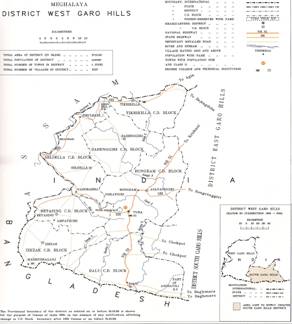
General features - West Garo Hills District
West Garo Hills is one of the largest district of Meghalaya located in the western part of the State. The Garo Hills district was divided into two districts, viz. the West Garo Hills district and the East Garo Hills district in October 1976. The erstwhile West Garo Hills district was further divided into two administrative districts of West and South Garo Hills on June 1992. The district headquarters of West Garo Hills is Tura, which is the second largest town in the State after Shillong. The district is bounded by the East Garo Hills district on the east, the South Garo Hills on the south-east, the Goalpara district of Assam on the north and north-west and Bangladesh on the south. The district is situated approximately between the latitudes 90° 30' and 89° 40' E, and the longitudes of 26° and 25° 20' N. The population is pre-dominantly inhabited by the Garos, a tribe with a matrilineal society belonging to the Bodo family of the Tibeto-Burman race tribes. Other indigenous inhabitants are the Hajong, Rabhas, Koches, Rajbansis, Meches, Kacharis and Dalus. The district is also inhabited by Bengalis, Assamese, Nepalese, Marwaries, Biharis and people from other parts of India. |
 |

